Geophysics in Chattanooga encompasses a suite of non-invasive subsurface investigation techniques that reveal what lies beneath the ground without the need for extensive excavation or drilling. This category of services is critical for engineers, developers, and environmental consultants working in a city where karst geology, variable soil profiles, and historic fill materials present significant geotechnical challenges. By measuring physical properties such as electrical resistivity, electromagnetic wave velocity, and seismic response, geophysical surveys provide essential data for foundation design, infrastructure planning, and hazard assessment. In a region shaped by the Tennessee River and flanked by the Appalachian foothills, understanding subsurface conditions is not just a technical requirement—it is a fundamental component of responsible development.
The local geology of Chattanooga is dominated by Paleozoic sedimentary rocks, primarily limestone and dolomite of the Knox Group and Chickamauga Limestone, which are highly susceptible to dissolution and the formation of voids, sinkholes, and pinnacled rock surfaces. Overlying these carbonates are varying thicknesses of residual clay, alluvial deposits along the river corridors, and anthropogenic fill in the historic downtown and industrial districts. This complex stratigraphy creates a subsurface environment where abrupt lateral changes in material stiffness, cavities, and groundwater pathways are common. Geophysical methods are uniquely suited to mapping these conditions efficiently across large areas, helping to identify potential geohazards that could compromise building foundations, retaining walls, or stormwater infrastructure.
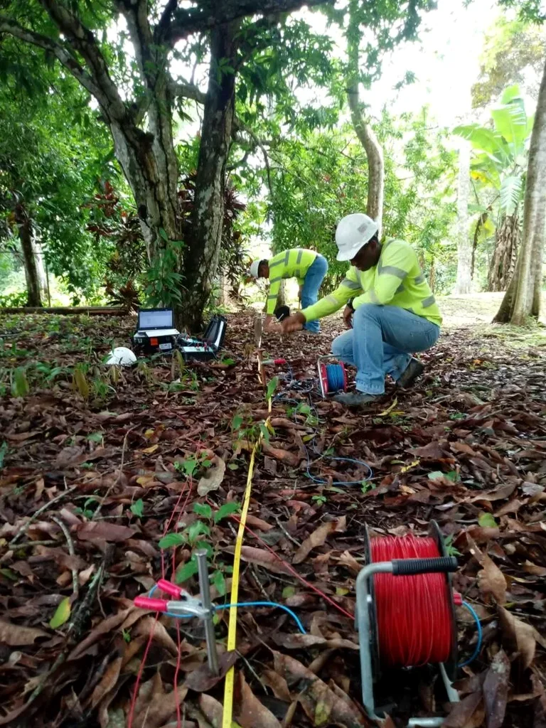
Geophysical investigations in Tennessee must align with standards established by the American Society for Testing and Materials (ASTM International) and the Tennessee Department of Environment and Conservation (TDEC), particularly when projects involve environmental site assessments or karst terrain evaluation. ASTM D6431 guides the application of electrical resistivity imaging, while ASTM D7128 covers ground penetrating radar for subsurface investigation. For seismic methods such as MASW / VS30 (shear wave velocity) profiling, ASTM D7400 and the International Building Code (IBC) reference shear wave velocity for seismic site classification. Local municipalities, including the City of Chattanooga, may require geophysical data as part of stormwater permits, grading plans, or sinkhole remediation designs, especially in areas mapped within karst hazard zones.
A wide range of project types in the Chattanooga area benefit from integrated geophysical surveys. Commercial and residential developments on undeveloped karst terrain frequently rely on electrical resistivity / VES (Vertical Electrical Sounding) to delineate soil-rock interfaces and detect air-filled or clay-filled cavities before construction begins. Transportation and utility corridor projects employ GPR (Ground Penetrating Radar) survey to locate buried infrastructure, map bedrock depth, and assess pavement integrity along highways and bridges. Industrial facilities undergoing environmental due diligence use geophysics to identify underground storage tanks, contaminant plumes, and preferential groundwater flow paths. Dam safety assessments, landslide investigations, and forensic studies of distressed structures also draw heavily on these non-destructive techniques to diagnose subsurface conditions without further disturbing sensitive sites.
Common questions
What is the primary purpose of a geophysical survey in Chattanooga's karst terrain?
The primary purpose is to non-invasively detect subsurface anomalies such as voids, sinkholes, and irregular bedrock topography that are common in the limestone and dolomite formations underlying the region. These surveys help engineers assess collapse risk, design appropriate foundations, and comply with local regulations for development in karst hazard zones.
How do geophysical methods complement traditional geotechnical drilling?
Geophysical methods provide continuous subsurface profiles between boreholes, revealing lateral variations that discrete drilling might miss. While drilling delivers point-specific soil and rock samples, geophysics maps the spatial extent of anomalies, optimizes borehole placement, and reduces overall investigation costs by covering larger areas efficiently.
Which ASTM standards govern geophysical investigations in Tennessee?
Key ASTM standards include D6431 for electrical resistivity imaging, D7128 for ground penetrating radar, and D7400 for seismic methods such as MASW. These standards ensure consistent data acquisition, processing, and interpretation, and are often referenced in geotechnical reports submitted to local authorities for permitting and design approval.
What types of projects typically require geophysical surveys in the Chattanooga area?
Projects commonly requiring geophysical surveys include commercial and residential developments on karst-prone land, transportation corridor expansions, utility routing, dam and levee safety assessments, environmental site characterizations, and forensic investigations of distressed structures. Any project where unknown subsurface conditions pose a risk to construction or long-term performance benefits from these methods.